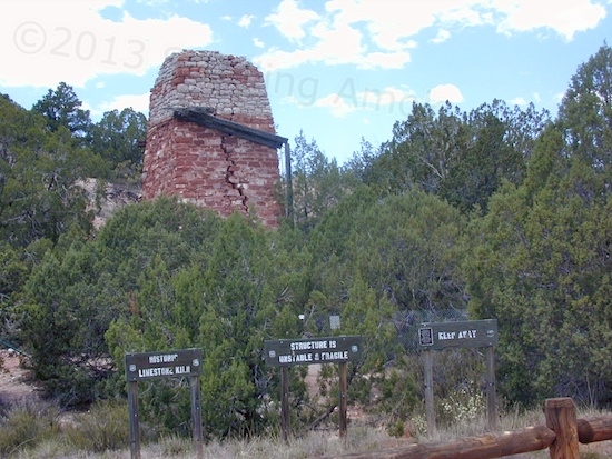
This old limestone kiln for making quicklime is falling apart, and will no doubt come down on its own, sooner or later. This is rugged land, so the labor to use it must have been amazing.
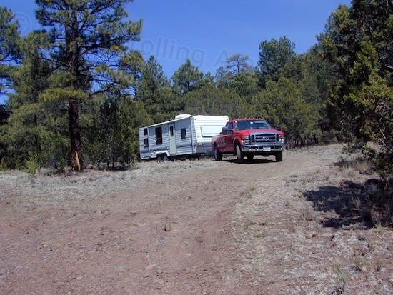
Yesterday was expended on touring a tiny selection of the forest roads in the northeastern section of the huge Prescott National Forest, north of Paulden. That, and having to head for the hardware store in Chino Valley once again in order to get a few mouse traps for the trailer. (I got one of the little buggers and turned him loose across the road in this morning.) The touring was considerably more fun. My goal was to get some idea of just how easy or tough it would be to find a usable camping spot in a National Forest, at least in this area. I had help and guidance finding the one I’m at. How difficult would it be going in blind?
As of this year, most of the National Forest roads have been closed off to motor vehicle access, which includes campers as well as all types of motorized vehicles. This is because four and two-wheelers have basically been tearing up wilderness areas, which causes water runoff problems and erosion. It gets a lot more complex than that, but you get the idea.

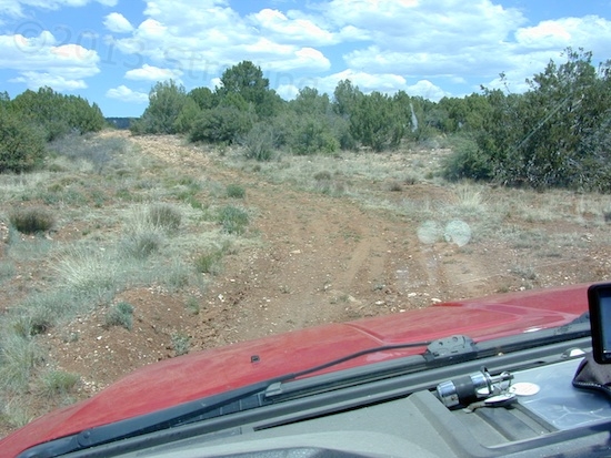
This section of FR573 looks great, but was a crawler in the F-250 because the rocky surface tended to toss me and everything else from side to side.
MVUM maps (motor vehicle usage maps) have been issued for most National Forests which show which roads are still available for travel and camping. There is a generic caution by experienced campers that forest roads are risky for trailers because of dead ends and lack of space to turn around. I just kind of pictured in my mind that the remaining approved roads would be comparatively trailer-friendly. Still a bit rough, still with dead ends that force backing up long distances, but probably a little less challenging for campers, when compared to the closed-off roads.
Yesterday’s tour unravelled that assumption! I’m on FR573, which actually goes for many miles, right up to the northern state line of Arizona. I took the loop around my area, FR9711D. I had taken FR9711C on my bicycle a few days ago, which looked like an impressively challenging 4WD trail due to severe erosion. I took FR573 northward for many miles, then I doubled back and crossed over Arizona 89 to tour forest roads on that side.

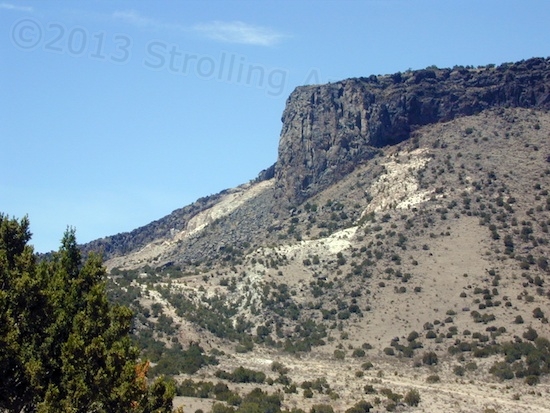
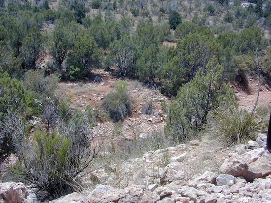
While on that section of rocks, I stopped to shoot the valley below. Pretty!
In general, there are no generalities about forest roads. As Forrest Gump would say, once you turn into one, you never know what you’re gonna get, and Google Maps gives no indication of roughness. A very few forest roads are broad, smooth gravel connectors. Others are the old, bypassed, gravel versions of current routes, like Arizona 89. The majority of forest roads are barely passable by travel trailer. The great majority are far too rough for a vintage TT. Many are too rugged for even a conventional, top-heavy truck camper. (A lightweight pop-up camper is the only safe option here because of rear overhang and center of gravity issues.) Some forest roads are suitable only for short-wheelbase, high-clearance 4WD vehicles like Jeeps.
Good thing there isn’t much traffic at all. While returning back down my tour of FR573 north, a couple in a newish modified Jeep Wrangler were coming the other way. Since this section of road was cut out of the side of a hill, the road was too narrow to pass. Fortunately for me, he was able to back off the road into a little niche way too small for me to fit into. Saved me having to back up quite a long ways.
The F-250 is simply too wide for many trails, and new branch scrapes on the paint show it. I wouldn’t go down some in the F-250 without my tow strap and a 4WD escort vehicle with a sturdy powertrain. A winch would be nice, but out here, “trees” are really just glorified bushes with no hope of moving 9,000 pounds of iron. As I’ve mentioned in another post, heading down challenging 4WD trails just for funsies is a calculated risk, and the F-250 is a big 4WD work truck, not a nimble off-roading device. Ground out, break, or get stuck, and your sole means of transport for water, food, and towing is unavailable, starting right now. The average tow truck can’t get to where you are. It’s potentially a very big deal, so from today’s tour, I’ve found that even MVUM-approved forest roads need to be approached with caution even in the F-250 alone. Much time was spent listening to the frame and body slowly flexing, a byproduct of the truck’s stiff springs.
That may seem distinctly unadventurous, but racer wannabe’s often find out the hard way why four-wheeling solo with stock equipment is asking for trouble. It’s a whole different scenario than an organized club tour. Get into trouble, and it’s just you, miles from anywhere. I’d actually like participating in a local off-road club event sometime (unloaded), but they all run modified Jeeps on trails much tougher and tighter than my whale can negotiate. It just isn’t in the cards.

The truck is directly over a multiple washout on FR9711D. Not the worst area, but my concern here was high-centering the long-wheelbase Ford, which has no protective shielding. I had to stop and pick my path first.
As for finding camping spots on forest roads, ditches running alongside them prevent pulling off the road with the trailer, and the great majority of potentials are unsuitable anyway because of uneven ground clogged with bushes and tall grasses. So, finding a suitable pull-off area for the Innsbruck can be quite a time-consuming challenge. The good news is that many forest roads are passable for some distance in, before a ditch or other obstruction causes a problem. Internet and personal advice are helpful but of limited value, because nearly everyone has better ground clearance than my rig, so their outlook tends to be overly optimistic. With 10.5 inches of ground clearance on a 9-foot overhang, I’m almost in 40-foot motorhome territory. Almost. Not a one would dare come in here.
All this means is that when intend to stay in an unfamiliar area of National Forest, I’m probably going to have to pull in and find a nearby spot to pull over. Then unhitch, and drive to survey the landscape. It’ll be a pain, but necessary until I can work up a list of “safe” spots during my travels.
My first chance to do this will be coming up in a few days. On Tuesday, I’ll be leaving this area and heading for Winslow, Arizona for an overnight in McHood Park. Then, on to Bluewater Lake State Park in New Mexico for an overnight there. That’s a pay site ($10), but since I’m considering wandering between all the New Mexico State Parks starting in the fall (after buying an annual pass), I’d like to check one out. Cibola National Forest near Grants NM will then be my home until May 27, when the Run Straight For Home begins.
Be advised that getting a cellular data signal in each of these locations could be a problem, so an update to this blog may take awhile!