
Just Out for a Walk
One thing you can’t say about this area is that it’s barren.
I took these shots in the same area, over two different walks I took. I would say that these are just some snaps I took with the Pentax K slung over my shoulder, but the majesty of writing for and publishing on a blog compels me to relabel the effort as a “photo essay”. Yeah, that’s right, photo essay, sure!
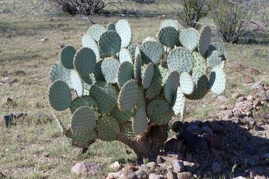
Love these things. Don’t know why. I feel compelled to name them, because each one is different. Like, this one would be “Fred”. Perhaps I should recheck my medications.

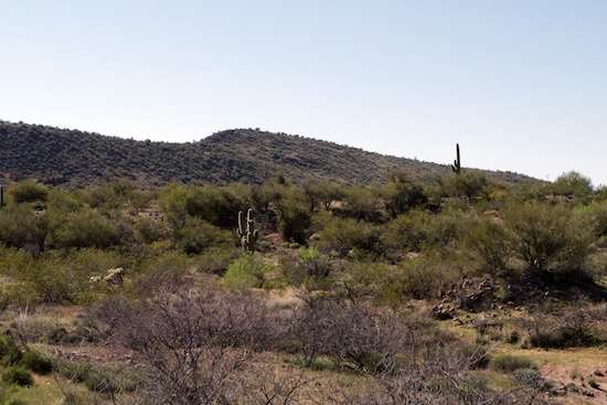
Just a hillside. Nothing spectacular, but you get the feel of the place.
And looking to the other side is a bit different. A side trail goes up into it.

How strange! I like these.

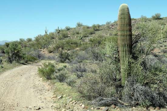
No way the Defiant’s going back in here! That’s too bad, because there’s a great camping spot a bit further on.
A Jeep trail up from an equine camping area up to near the top of a ridge poses a challenge.

These are all over the place here!
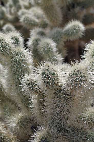
The way the sun glints off the needles is remarkable to me.

Pretty well-defended, I’d say. This shot’s a little off, since I relied on autofocus with maximum aperture, a sure recipe for not getting just what you want. The closest needles are supposed to be sharply in focus, not the ones an inch further back. It’s what being lazy gets you!
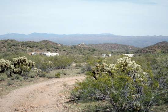
Looking back toward camp, the Defiant is the furthest to the left. It looks tiny compared to the motorhomes and fifth-wheels around it.

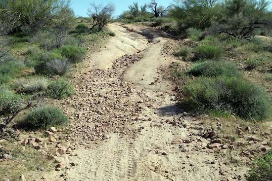
Here’s one drop into a wash that was tricky to even walk!

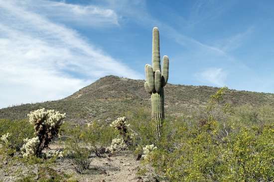
The Wickenburg area is tops, in my book.

A lot of mining once took place in the area, and that’s the only way I can explain acres of ground like this.

This is actually right next to the trailer. Lots of sharp edges. You can be sure I don’t go pounding down trails in the truck here, seeing as how the tires are 7 years old and look it.

This has seen better days. It refuses to snap off in the wind, though.
This newer version on the opposite side of the trail looks a little more sprightly.
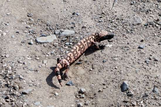
In the Southwest, I’ve seen big honking unidentified spiders, a tarantula ambling along, and now this gila monster. He was just over a foot long and stayed put until I was out of sight.

Doug
Sure looks nice there……autofocus, whats that?
My lens just picked up a piece of sand and now will not move. ?..down to smart phone or tablet.
Anyway, its wind today on Lake Mead white caps galore.
Papa
http://www.papas-travels.blogspot.com
Ohhh, that’s not good. Couple of times now, I’ve appreciated my camera’s body and lenses being weather-sealed, after my previous adventures with vintage film SLRs in the field. Nothing quite like that crunching sound as you rotate the lens. Yum!
Last Fall, I tried going through Lake Mead to scout it for future stays as I headed toward Quartzsite, and it was closed, with entrances barricaded off! Government shutdown. Glad it’s open for business for you!
Nice Monster.
Yep. Been awhile – quite awhile – since I last saw Disney’s Living Desert series. Like, half a century. I had forgotten they existed, and so was surprised to see one.
Do you realize how lucky you are to encounter a Gila Monster? And he just stayed in place posing for you- amazing!
Yup, I assume he was thinking he’d blend in unseen.
That rocky ground outside Defiant made my ankles hurt just looking at them. I prefer pebbles. But either is better than the snow we still have here in Minnesota. Hopefully next winter I will be back in the desert.
I thought you made it out here! Did you have to cut short? The usable camper surfaces are pretty well cleared Linda, so don’t wince or dread. But do watch your step.
Yes, I did and yes I did. Made it out there but got sick and had to come home late December. It’s been a long winter and it is snowing right now.
Oh, I’m sorry to hear that, especially considering the type of winter you returned to. May your future travels be less challenging!
Great Pictures I love Photo essays
Thanks, Linda. Someday I’m going to have to get happy with making some kind of way to display larger versions of such shots.
You are a very fortunate person as you spotted the gila monster. In the 13 years I have been crossing the southwest and a lot of miles on the hiking trails of Arizona, I have only had the opportunity to meet a gila monster twice in all that time.
Wow! I hate to think that may be it Lloyd, since my walks are not decent hikes, nor frequent. But it was a big surprise, and I’m glad I had the camera. Should’ve taken a low-angle shot, but back-thinking a chance encounter is so common for me. Woulda’-coulda’-shoulda’.
Doug:
I read your comments on how to know where the borders are on State Land in Arizona.
A useful tool for finding camping spots and land ownership in the west are the FREE maps for most any Garmin GPS at “GPS File Depot”. Yes Free.
There are also State Topo maps and land ownership for some eastern states as well.
I have a Garmin Nuvi auto GPS and always have the land ownership maps running while driving. This one is for the western states and will install as an overlay to the road map that comes with your unit. The colors of the overlays are the same as the Benchmark maps but there is much more detail.
http://www.gpsfiledepot.com/maps/view/247/download/
State: Arizona, Colorado, Montana, New Mexico, North Dakota, Oregon, South Dakota, Utah, Washington, Wyoming
Price: Free
There are free maps of all types for all over the world at this site, and detailed instructions on how to install. Basically you download the installation program to your PC or Mac. Run the installation program which puts the map in a directory on your computer. Buy a micro SD card for your Garmin. Insert into port on GPS. Then copy the map to a New directory on SD card called “Map”.
It will then appear on your GPS and can then be turned off or on by going to settings/map/info.
Ooooh! That’s a four-letter word I happen to love! Free! Seriously, thanks John. I will check that out, as it seems like an extremely worthwhile addition.
Glad to help. Let me know when you get it installed, and if you had any problems.
I like the sounds of this, too. Good things I have Windows installed on my Mac, though, since this is a Windows app. I have Dave looking into details for me. Thanks for the link.
Try this link which gives you a choice between PC and Mac downloads.
Whops! Forgot to copy the link.
http://www.gpsfiledepot.com/maps/view/247
Woof! Got things installed after some confusion and held breath. I have an iMac that never saw my Nuvi 265W before. After downloading the Western Ownership map, I opened it with Archive Utility to decompress it and let it become a gmapi file. Wound up installing Garmin WebUpdater, BaseCamp, and the GPSMapDepot MapInstall and MapManager. Things were a bit of a tussle at GPSMapDepot because of the usual nonexistent choices shown in the instructions, even for what was supposed to be Mac instructions. In order to avoid screwing up my GPS, I wound up putting the Western Ownership map on an SD card and plugged it into the GPS, and it automatically showed the built-in Navigator map and the Ownership overlay together, which was nice. Works well. Garmin BaseCamp, which allows viewing and trip planning on the iMac, unfortunately can only view one map at a time from the GPS, so it’s possible to zoom in and flip back and forth to get a rough estimate, but not too handy near an ownership border. But that’s Garmin. The Ownership map on the GPS is great though, and works like a charm. Thanks, John!
Doug:
Thanks for getting back to me about the problems installing the Map ownership file. Basecamp is a bit cumbersome to use but at least it allows one to Browse the maps on a bigger screen than The GPS.
Your idea to copy the map directly to the SD card first, with the card installed in the computer, is a good one. It sure sounds less confusing. I’ll change my instructions to anyone else, so that maybe first time users will have a less frustrating time.
There are lots of other maps at that site and a few other sites that I have found. The land ownership in California is built into the Topo map of California, but it is not a transparent map, so the road map has to be turned off. And the topo maps of other states are not transparent, but have more jeep trails than the Standard road map so they may be useful in knowing exactly where you are if “off roading”.
And there are free Maps of Mexico, and Canada. If they were not included in your Garmin, you can add them.
Regards John
On Fri, 28 Mar 2014 10:58:03 -0500, Strolling Amok
Well, one of the instruction sets already describes the choices of GPS or SD card, and I simply chose the SD card route since I was afraid of some unexpected install behavior that I wouldn’t be able to recover from, trashing my rather vital GPS’s internal map. Once I skimmed and read about how the software could combine several maps into one and then send it to the GPS, I immediately freaked without rereading it to understand what it meant, and looked for the option that would avoid that. As I recall, once MapInstall did its thing and MapManager followed, the world became a better place as far as the GPS is concerned. I’m not sure I’d alter those instructions much since not everyone has a spare SD card laying around.
My main interest in any instructions that actually involve multiple pieces of software is to understand what each basically does, how they relate to each other (if at all) as far as the end goal is concerned, and in what order each must be installed or already be present in order to avoid that little window that pops up and announces that some install has aborted or stopped because something is missing. My initial start was to find that decompressing the TAR download to a GMAPI format didn’t open any window automatically, so I had to start guessing which software package would have engaged it had it been automatic. “Technically, where am I supposed to be right now?” As a three-decade DOS and Win end-user, I was supremely used to troubleshooting why something wasn’t working. As a five-year Mac user, having to make the computer happy first in order to get your work done is a forgotten art. There’s no practical way I can see as to how you’re going to stay current with Mac menu choices in BaseCamp, since they’ll keep altering their software over time like everyone else. The helpful part in the instructions is that I can pick up on what it is you’re going for, and then dig around on my version looking for something likely to perform the same function. I got there. I’m happy, and delighted with how it works on my Nuvi. Thank you!
Doug:
I am also an old Dos user. At least 30 years. In fact I still use it on this laptop to keep text notes on places to camp. I also have a devoted computer at home which still keeps all my financial records.
I got involved in converting a web browser from unix to Dos in the early 90’s but have not been keeping up with much with any technical depth since going on the road 17 years ago. I finally got forced to adopt windows (7) with this laptop which came free when I signed up for 2 years broadband at a Best-Buy store a few years ago.
I am a text and information guy, and still use opera Browser with graphics turned off to minimize data downloads. It really helps on slow connections from remote locations and allows me to select what I view if it looks interesting.
Linda Sand is interested in getting the GPS fixed up also. Now that you have it working I am sure you will be able to work her through it.
I am not a blog guy. Like to lurk but rarely comment unless I think I can help. Your problem with determining State Land borders got me to “come out”.
Question: When I reply to your email, it does not appear on the blog comments, but when I reply inside the blog it appears. Why?
Regards John
On Fri, 28 Mar 2014 16:26:13 -0500, Strolling Amok
I’ll answer your blog question first John, because that answer is easy: I don’t know. But I would guess that email is email, and the blog is the blog. Click reply in the blog, and it posts your message. Click reply in whatever notification email appears in your mailbox, and it’s treated as email. What I wonder about is, if you replied by email, where did it go? I’m not seeing anything anywhere. Must be a configuration issue in the Strolling Amok blog. Hmmm.
Glad I managed to lure you into commenting on your map and instructions. They are supremely handy, and I thank you for chiming in.
As for installation, I wound up doing it again after booting up this morning and seeing nothing in particular when viewing the Western Ownership overlay. Suspecting I might have damaged it by not ejecting the card properly the day before, I used Garmin MapManager to delete it, and then cleared it from the Trash. Garmin MapInstall could then see the card, but complained that there were no unlocked maps in sight. I found no way around this except to right-click on the Western Ownership.gmapi file itself, and Garmin MapManager offered to open it. Yay! A tiny window popped up asking whether to install the map, and selecting Yes unlocked and “installed” it. But the installed map was on Garmin’s turf on the main hard drive, not on the SD card. So I opened MapInstall, which now saw the card AND the map, so I clicked Continue. The screen allowing you to select what areas to install came up. Picking all eight of them and selecting Send Maps and then Continue did the trick.
In Garmin BaseCamp, I actually seemed to have both the City Navigator map and the Western Ownership overlay display together – at least for awhile. I had selected my particular model of GPS in the list to the left, rather than any map listed underneath it. I then selected the menu item Maps along the top and then Western Ownership. Presto. Both maps visually blended. After clicking other selections though, it went back to one-map-only and I haven’t gotten it back (so far). But BaseCamp is a bit funky in how it chooses to edit what it displays, so I may get both back, or maybe not. Still, me happy! Thanks!
For anyone that is looking for an SD card, be sure to get a micro-SD which comes with an adapter that allows use also with a full size SD port usually found on a computer. Buying the card allows installation on the GPS without tying up normal working space that comes with the GPS. And if there are any problems, just pull out the card. A 4 Gig card is more than adequate and has space for many more maps if you feel like adding additional. It should cost less than $10. I saw 2 for $12 at a Walmart the other day.
Other free map sites for Garmin GPS which may be interest:
http://www.osmmaps.com/
http://mapas.alternativaslibres.es/downloads.php
http://www.gpsfiledepot.com/maps/
On Fri, 28 Mar 2014 16:26:13 -0500, Strolling Amok
John, you clever dog! And thanks for the links, too!
My current SD card does not fit in my GPS. Looks like I may be going shopping for a mini SD card soon. I really want this software.
Well, you won’t need a big one – the map takes up less than 50MB on mine. I’m using an ancient 256MB card that I’m sure you can’t find any more.
I’m a newbie and a lurker who appreciates the wealth of helpful information on this blog post… thanks Doug and John. I would also like to read the “comments on how to know where the borders are on State Land in AZ” – what was the post date?
Lurking is good, Susan. Also, being a newbie. That post John was referring to is here, or you can simply go to the home page and look for Wheezing in Wickenburg. My “comments” there may be more like whining than helpful info, however. But who knows? You might enjoy it. If you have any questions after you read it, chime in!
I have learned so much from all the generous bloggers on the road. It’s so much easier than trying to reinvent the wheel by myself. Thanks for you speedy reply.
I agree. It’s so much more pleasant to learn from other people’s mistakes than my own!
Doug: I don’t want to be accused of hijacking your blog but since I have seen a bit of interest in Garmin stuff, perhaps if you are willing, I may post some more.
I have some more tricks I found for the Garmin. I have to move tomorrow to a spot a little more easterly. I’ll think about what to say while driving if anyone is still interested.
Have been wintering in Arizona etc and am now at a Boondocking spot on Lake Whitney in Texas. Going to move east of Dallas to another free spot on a lake that we have heard about. Hopefully the weather will still be good and I can enjoy another few days there.
Regards John
On Sun, 30 Mar 2014 18:56:10 -0500, Strolling Amok
Well, including interesting and helpful information does undermine the original goals of Strolling Amok, but I’m willing to experiment. 😉 Instead of packing in comments, why not jot down what comes to you and email me via the Contact Page. I’ll “invite” you as a contributor, and you can access the blog and work on your post as your own time allows until you’re happy with it. Once you feel you’re done, I can publish it. If you can respond to comments, so much the better! It doesn’t have to all be packed into one post. You can also do tidbits or sections, if you like. Does that work for you? For all I care, you can take a snap of Lake Whitney and write one about that, too! It’s all good.