
The Victory Highway

This recreation of an original Eagle casting shows what was planted at every county line along the Victory Highway, and only five originals are known to exist today.
The Victory Highway was was an amalgamation of early trails and pre-existing roads that ran from New York to San Francisco, and was based on everything from Indian trails to the 1912 National Old Trails Road, one of the first official automobile routes going from coast to coast. The Victory Highway was dedicated on June 25th, 1925 to the memory of the men and women who gave their lives in World War I. The ceremony took place in Wendover.
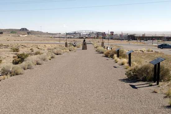
There are occasional vestiges of the Victory Highway, but this piece that is several hundred yards long, is the only preserved piece I know of. Even it is interrupted by streets to reach the West Wendover city building, however.
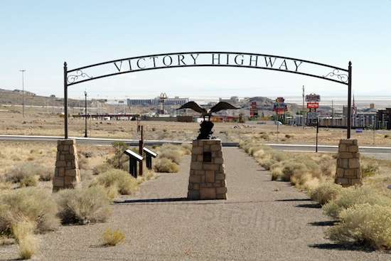
No, the sign is not original, but is a much nicer version of the original one used to dedicate the road during its dedication in 1925.
East of St. Louis, it got little publicity, since it was effectively just a renaming of the existing National Old Trails Road. Out West however, it was a bigger deal. Part of that was because it crossed the Bonneville Salt Flats, which was the equivalent of crossing a salt bog that was often underwater.
In Utah at least, little of the Victory highway was paved, and much of it remained “unimproved”. That means that it remained two bare ruts across the scrub brush desert. The section in these photos is “improved”. That’s significant to me because, although automobiles had found their final configuration long since and were fairly reliable, tires and tubes remained a big issue that would remain problematic for decades. Such details as the materials used in sealing gaskets and hoses were improving, but far from the bulletproof items they are today. So, blithely taking on the sparsely-populated Western section in 1925 would be a bad idea. We’re so far removed from this “be prepared”, vigilant mindset today that exchanging places as drivers to each other’s era would be a revelation, I think. The 1925 driver would be astounded to the point of being speechless at the event-free crossing, even in a twenty or thirty-year-old junker we were glad to get rid of. He’d also be amazed at the frequent availability of supplies and repair. The 2014 driver would tend to be still out there somewhere, quickly short of water and with no way to repair tires, leaky hoses or blown gaskets. But, even with the proper mindset, many drivers in 1925 were still caught by surprise when tackling the worst sections, and some paid the price. Death by dehydration is not a pleasant way to go, despite the “getting weak and falling asleep” depiction universally used in movies. Not a first choice.

This commemorative section of the Victory Highway also memorializes one the main trails used by pioneers to reach points west and California.
Not to harp on this, but the BLM cautions visitors making the tour of the 52-mile loop around the Silver Island Mountains near the Bonneville Salt flats to pack extra water, make sure the gas tank is nearly full, and to let someone else know that you’re on the loop that day. We tend to mentally disregard that because we are so used to modern reliability that the odds of a mishap seem so remote. They are remote, now. But even having been out here awhile, I’m still amazed at how much water I can go through in a short 4-mile walk. The desiccating effects of the hot, dry air and sun continually surprise me, and with the cruder state of thin bicycle tires, making similar car-like assumptions about reliability can make for a very unpleasant walk back to the starting point.

A section of unmarked US 40. Wendover is several miles west. This section is not maintained any more, since it runs parallel to and alongside I-80. There are broad potholes and numerous areas where the foundation underneath has collapsed, creating deep sinks that aren’t noticeable at speed.
The Victory Highway had to be replaced in the 1940s by US 40, which either went on top of it or closely paralleled it. With the Second World War being on, truck transport no doubt pushed the primitive highway past its limits and a serious, modern roadway had to take over the job. In Wendover proper, US 40 paralleled it and the old highway was abandoned and left for dead, much of it being torn up to allow expansion of the town itself. US 40 is now dubbed Wendover Boulevard, and is the main drag through town. Decommissioned as a highway, no US 40 markers remain here.
I-80 has since taken over from US 40, and east of town is an unmarked two-lane that parallels I-80 for many, many miles. I strongly suspect that this roadway is the Victory Highway, topped by US 40. This is simply because engineering the lift over the salt flats on a second path would be mighty expensive. It’s used now merely as access to a potash business east of town, and once past an interchange four miles from the Utah-Nevada border, it is abandoned. Time and flooding have not been kind to this relic of US 40. Its foundation has weakened, resulting in numerous sinks and dips, as well as loss of the top layer of pavement in spots. Driving it in the F-250 is a 20 MPH affair at best, dodging this way and that to avoid the deeper sinks, which are hard to see in time. Unlike the Old Route 89 affair near Paulden, Arizona that I waxed so romantically on about, this section of VH/US 40 is best appreciated on the ground, admiring its arrow-straight perseverance over the muddy salt flats. I found myself getting few buzzy vibes from it, probably because it’s simply deteriorating asphalt laid over a primal roadway in a featureless terrain, and the very significant engineering feat of topping the Salt Flats has finally lost its battle with Nature.
Oddly, the short, original section of the Victory Highway in town struck me as nice, but didn’t light my ancient roadway fire either. Maybe it’s because it is the original path, but one which has been truncated and restored especially for display purposes. It’s nice to see it restored to like-new condition, especially since its 1925 commemoration service took place somewhere nearby, but somehow, lacking the wear and tear of actual use robs it of something that I can’t otherwise define. I can’t “feel” the sparse traffic it once held. Like the bronze eagle that adorns it, it smacks of being a re-creation. Glad I saw it? Yes. Historic? Yes. But perhaps it’s something akin to going to a special restaurant, expecting subtle layers of flavor in the dish, and finding that it provides little more spark than what you can find at the family eatery just down the road. Maybe I’ll look around nearby on my next visit, and look for an elusive remnant of the Victory Highway that stands alone and reveals its past in that odd, “this happened here” way. Restored displays just don’t do it for me, I guess.

I remember being out in the desert as a kid and the canvas water bag hung off the car.
Rob, a couple of those canvas bags were hung off one of the military vehicles on display at the Wendover Air Show. I’d never seen one before. Thanks for the comment!
The old roads….
The Eisenhower interstates did a lot towards the growth we had in the late 1900’s, I remember driving to Eugene Oregon from California way back then, all on little roads with concrete mile marker posts by the side of the road. The trip took forever…. of course I was only 5 or so…
I spent my time on Route 66 heading for Missouri from Chicagoland, with death-defying passing maneuvers and the car lifting at lot at the crest of each hill. And Howard Johnsons & Stuckey’s stops, and all those Burma Shave signs. Adventure! Thanks, Rob.